North South Shared Path
Frequently Asked Questions
The North South shared path grant application is part of Port Augusta City Council’s efforts to enhance wellbeing through the implementation of shared paths in the city. These paths are designed to promote exercise, improve health, and create a better tourist experience. Council has developed a vision to establish a network of shared paths throughout the city, with the main route being called the North South Shared Path.

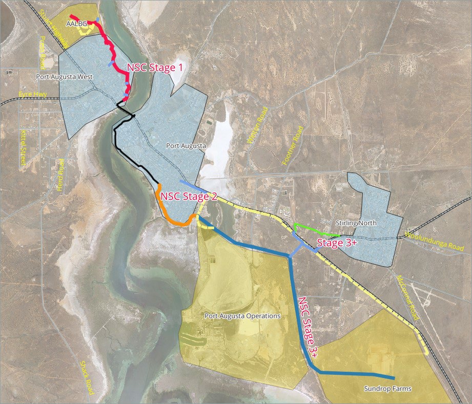
| Existing fully constructed paths shown in Black | ~ 4km |
| Paths requiring moderate to significant work shown in Red | ~ 3.5km |
| New paths requiring full construction shown in Brown and Blue | ~12.5km |
Stage 1 of the vision focuses on upgrading the existing shared path north of the Joy Baluch AM Bridge to the Australian Arid Lands Botanic Garden (AALBG). The council has applied for funding from the Growing Regions Program to cover 50% of the $2 million needed for this upgrade. The proposed improvements include widening the path to at least 2.5m, sealing the path, building a crossing of Gardiner Avenue, creating a hard surface path on the beach, extending the path through the AALBG to the information centre, and installing solar lighting at key points along the path.
Further stages of the North South shared path are also proposed, which would connect different areas of the city such as Larkin Crescent, Stirling North, and Sundrop Farms. Additionally, the council has received funding for Stage 1 of the Westside Link project, which aims to connect Addison Road to the Joy Baluch AM Bridge.
Shared paths have many benefits including their ability to encourage alternatives to motor vehicles, promote walking and cycling, and improve the health and wellbeing of residents. The ultimate goal is to establish a comprehensive shared path network that extends from AALBG to Sundrop Farms and beyond.
Q: What is the purpose of the North South Shared Path in Port Augusta?
A: The purpose of the North South shared path is to create a continuous path suitable for pedestrians, cyclists, eBikes and scooters, linking various areas including the Port Augusta Activity Centre, Australian Arid Lands Botanic Gardens (AALBG), Sundrop Farms, and Stirling North.
Q: What permissions are required for the development of the shared path?
A: Permissions related to native vegetation and Native Title are required. Council has care and control over the land west of the gulf (Port Augusta West) and west of Bird Lake. The section along the highway is under the care and control of the Department of Infrastructure and Transport. Council proposes using unopened road reserves through the PAO lands. Land to the right of the highway is also an option.
Q: Is there support from stakeholders for the shared path project?
A: Yes, the operator of Sundrop Farms is supportive of the project, and it is anticipated that a proportion of their workforce would use the path with bicycles or eBikes and scooters. The AALBG advisory group has also expressed support for a path through the AALBG lands in principle.
Q: What are the specifications for the proposed shared path?
A: The proposed cycleway would be 3.5 meters wide with a minimum 0.5-meter shoulder. It will be sealed and designed for both pedestrian and cyclist use, as well as eBikes and scooters. It will primarily accommodate dual-directional traffic.
Q: What is the estimated cost of the North South shared path project?
A: Council is progressing the project in stages and subject to successfully achieving grant funding. Stage One (1) of the project has an estimated cost of $2M and Council has applied for 50% funding. The total estimated cost for the entire North South Shared Path is $6M for which grant funding will be sought and progressed over time.
Q: What areas will be covered by the shared path?
A: The shared path will cover a range of areas, including the Port Augusta Activity Centre, AALBG, Sundrop Farms, and Stirling North. Existing paths that are suitable for shared use will be utilised, while other paths will be upgraded or constructed to complete the route.
Q: How will the shared path connect to Sundrop Farms?
A: Two options are being considered for the connection to Sundrop Farms. One option is to use the highway route, while the other option is through the former Flinders Power Station lands. Initially, the preference is for the highway option, but discussions with stakeholders are ongoing.
Q: Are there plans to expand the shared path beyond Stirling North?
A: There are potential plans to extend the shared path beyond Stirling North, with a potential link to Melrose SA, where a bicycle culture is flourishing. However, the exact expansion stages beyond Stirling North have not been determined at this point in time.
